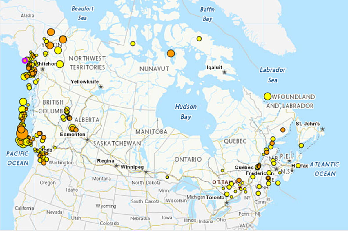
Nearly 400 earthquakes shook various regions of Canada last month, but only a handful were noticeable—at least to humans.
“It is a pretty typical month,” said John Cassidy, an earthquake seismologist with Natural Resources Canada. Cassidy works with the national earthquake hazard project based in Victoria.
The west coast of Canada is one of the most active areas for earthquakes, with approximately 80 percent of Canada’s earthquakes happening along the Pacific Coast.
Even May 1–2 there had been 22 earthquakes recorded, including three west of Tofino and Port Hardy, and another south of Port Renfrew on Vancouver Island. A magnitude 3.6 earthquake near Mount Vernon, Wash., was felt in the early-morning hours of May 1. The quake was 80 kilometres away from Victoria and nearly equidistant with Seattle and Vancouver.
“We see 4,000 to 5,000 earthquakes located across Canada each year. There’s undoubtedly more than that because those are the located ones,” said Cassidy. Earthquakes that are picked up by seismographs are usually magnitude 2.0 to 2.5 or larger.
388 #earthquakes across #Canada during the past month. A typical pattern with ~80% of the earthquakes on/near the active plate boundaries of western Canada. The largest was M5.3 (offshore Vancouver Island) and only a few were felt this month.
Details:https://t.co/XeGlkk7c7C pic.twitter.com/n9A963qRlQ— John Cassidy (@earthquakeguy) April 28, 2022
“Almost all of those are tiny and not felt.”
There are typically three dozen earthquakes felt across Canada every year, and that number has remained constant for the past two decades.
Most of the earthquakes that occur on the west coast do so because tectonic plates underneath land and sea move and shift along active fault lines. Tectonic plates are slabs of solid rock, some larger than a continent, that shift slowly and change the topography of Earth.
RELATED: Vancouver Island slides west, tremors could signal tectonic shifting
In southwestern B.C., for instance, the Explorer and Juan de Fuca plates are “shifting” underneath another called the North American Plate. They’re moving somewhere between two and four centimetres per year, according to Cassidy.
Did you feel shaking in northwest #WA and southwest #BritishColumbia at 4:16 this morning? Many people did.
That was a M3.6 earthquake near Mount Vernon – nearly midway between Seattle (90 km), Victoria (80 km) and Vancouver (110 km).
Details from #PNSN: https://t.co/url2Wzyu7A pic.twitter.com/uHLOYRRzBr— John Cassidy (@earthquakeguy) May 1, 2022
Another natural event that has been occurring on—or perhaps more suitably ‘under’—Vancouver Island lately is something called episodic tremor and slip. They’re likened to ground vibrations, similar to windstorms.
More than 6,000 of these events were recorded between March 20 and April 7. They are not felt, and they happen every 14 months or so, according to Cassidy.
These “ETS” started in September 2021 in the southern Vancouver Island and Northern Washington State regions, according to the Pacific Northwest Seismic Network.
The curious thing, says Cassidy, is very little is known about the correlation between earthquakes and episodic tremors. “We don’t think there’s any link,” he said, “but it’s something we’re still actively working on.”
Episodic tremors were discovered about 20 years ago here on Vancouver Island. They have been found to run along the subduction zone, which follows the coast line and is approximately 100 kilometres wide. Similar episodic tremors and slip are happening at subduction zones around the world, he added.
Only 67 tiny ETS tremors (not felt) on southern #VancouverIsland today – perhaps ETS is winding down! Nearly 6000 tremors have occurred here since March 20th.
More on Episodic Tremor and Slip (ETS):https://t.co/M6SpDesBEohttps://t.co/s1yZjkMDxwhttps://t.co/pt0MGPzJ7b pic.twitter.com/5ayqY0Qqet— John Cassidy (@earthquakeguy) April 8, 2022
Cassidy said the number of earthquakes recorded in April, coupled with the number of episodic tremors, is a good reminder that we live in a seismically active zone, but said there is nothing out of character. “They’re both typical patterns. Nothing unusual,” he said.
There are few places that don’t experience earthquakes: one would have to move to the prairies for that, said Cassidy. Saskatchewan and Manitoba, as well as parts of the country under the Canadian Shield (Laurentian Plateau) rarely feel earthquakes because they are farthest away from tectonic plate movement.
We feel them more on the west coast because Vancouver Island is situated within an earthquake zone.
“Earthquakes are happening each and every day,” he said. Some of the damaging earthquakes happen “every decade or two.”
Devastating earthquakes, such as one that hit the Comox Valley area in 1946, fade from memory because they don’t happen all the time. “It’s easy to forget about those events but they do happen and they will happen. It’s good to take advantage of the reminder that we live in an area that has seen large earthquakes,” Cassidy said.
He said there are websites such as EmergencyInfoBC or Shakeout BC that have information on how to prepare in the event of an earthquake. He suggested keeping a flashlight and slippers or shoes by the bed, so you have a way to see and protect your feet from debris on the floor following a serious earthquake.
“That’s our message, is not to be afraid or worried but to be prepared.”
Earthquakes Canada uses the information its seismologists collect to help builders and emergency managers know what to expect for future events.
“That’s really the goal of all the work that we do is to minimize the impact of earthquakes we may have in the future.”
susie.quinn@albernivalleynews.com
Like us on Facebook and follow us on Twitter
Alberni ValleyBritish ColumbiaEarthquakeEmergency Preparednessvancouverisland

