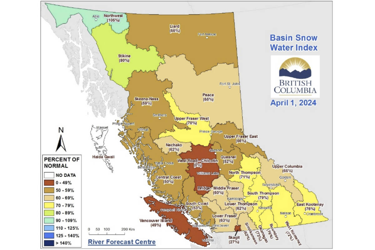
The provincial snowpack is now at the lowest level since 1970 for April 1, raising serious concerns of drought, although experts says it’s too soon to say what will happen for certain.
Jonathan Boyd, a hydrologist with the B.C. River Forecast Centre, said Wednesday (April 10) that many factors contribute to droughts. “It’s a little bit too early to say with definity that we will for sure have a major drought this year,” Boyd said.
The centre’s latest report show snowpack levels are 63 per cent of normal on average across B.C., the lowest recorded figure for April 1. Boyd said 1970 is the furthest year back they have full provincial data for, but that it’s possible this month’s levels break even older records.
The April 1 figure is down three per cent from the 66 per cent recorded on March 1 and an even more significant drop from April 1, 2023 when the snowpack was 88 per cent of normal. The previous low point for April 1 was in 2015 when levels were at 66 per cent of normal.
Boyd said experts consider April’s snow survey and water bulletin to be the “premier” report for assessing the year’s seasonal snowpack and historical comparisons.
“Typically, by April 1, about 95 per cent of the seasonal season has accumulated,” Boyd said.
READ ALSO: Precipitation still at a deficit as B.C. nears 2024 wildfire season
READ ALSO: B.C. residents asked to prepare for a “challenging” wildfire season
While snow levels could continue to climb into May, the snowpack so far has followed the patterns of a typical El Nino year with a warmer-than-normal and sometimes drier-than-normal winter, Boyd said.
“It’s not setting up for a great season, but it just depends on what the weather conditions are,” he added. “If we have last year’s spring weather conditions this year, it will be worse from a drought perspective,” he said.
Regions with the lowest snowpack currently include the Chilcotin (0 per cent of normal) and Vancouver Island (49 per cent of normal). Areas along the central and southern coast, Skeena-Nass, the Northeast and the Upper Fraser East and Quesnel regions all sit between 50 and 59 per cent of normal.
B.C.’s most northwestern corner around Atlin is the region in the best shape at 105 per cent of normal.
Overall, the River Forecast Centre described snowpack levels as “extremely low” and warned this, combined with a forecast of above normal spring and summer temperatures, could “significantly elevated drought hazards.”
But Boyd said it’s still possible things could change in the weeks to come. He pointed to years, such as 2022, that experienced drought despite a healthy snowpack and years, such as 2019, when predictions of drought did not materialize because of summer precipitation, leading to serious flooding.
The centre will release its next update on May 9.
Nathan Cullen, minister of water, land and resource stewardship, said in a statement that the latest levels are “concerning news.”
“Communities around B.C. experienced serious drought conditions last summer,” he said. “It fuelled the worst wildfire season ever, harmed fish and wildlife, and affected farmers, ranchers, First Nations and industry.”
But if the current snowpack level is “not good,” Cullen warned also against too much gloom and doom. “There (are) a lot of things we can do individually, collectively, at different orders of government,” he said, pointing to various initiatives.
But businesses and individuals will also have to play their part, he added. Heavy industrial water users have already faced restrictions, he said. “But we are trying to stay away from water restrictions as best as we can,” he said.

