The south coast of B.C. faces potential flooding as a series of rainstorms is set to descend on the region starting Saturday (Jan. 27).
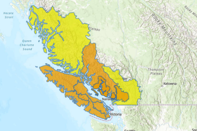
As the first atmospheric river of the year approaches, the BC River Forecast Centre issued flood watches for Vancouver Island, the south coast, Sunshine coast, Sea-to-Sky, North Shore mountains and the Fraser Valley north including Port Coquitlam to Harrison.
A flood watch means that river levels are rising and are expected to reach or exceed their banks and nearby flooding could occur. As of Friday morning there were no flood warnings – where river levels have exceeded, or are expected to exceed their banks.
READS ALSO: Simple steps for preparedness
There are high stream advisories for lower Fraser tributaries and central coast, meaning river levels are rising or expected to rise rapidly, without major flooding. Fast-flowing bodies of water increase risk to life safety, the advisory issued Jan. 25 noted. Minor flooding in low-lying areas is possible.
Narrow bands of heavy precipitation are common in the province, most frequently in the fall and winter, notes Environment Canada.
The series of rainstorms starting Jan. 27 are expected to continue through Wednesday Jan. 31 and accumulating as much as 300 millimetres on West Vancouver Island and in the Coast Mountains; 250 mm in the Howe Sound area; 150 mm in inland Vancouver Island; 120 mm in the Fraser Valley (Abbotsford to Chilliwack), Sea to Sky and North and Central Coast areas; and 60 mm in the Southern Gulf Islands, Fraser Valley (Hope), Fraser Canyon and the Coquihalla regions.
READ ALSO: Colder, winter months can lead to uptick in carbon monoxide poisonings
FLOOD WATCH issued by #BC River Forecast Centre for:
-S. Coast including Howe Sound, #SunshineCoast, #SeatoSky & N. Shore Mountains
-Fraser Valley N. including tributaries from #PortCoquitlam to Harrison
–#VancouverIsland
More info: https://t.co/6KPoIrb6f5 #BCFlood pic.twitter.com/KMYkg2Vi6M— Emergency Info BC (@EmergencyInfoBC) January 25, 2024

